Detecting methane emissions during COVID-19
While carbon dioxide is more abundant in the atmosphere and therefore more commonly associated with global warming, methane is around 30 times more potent as a heat-trapping gas. Given its importance, Canadian company GHGSat have worked in collaboration with the Sentinel-5P team at SRON Netherlands Institute for Space Research to investigate hotspots of methane emissions during COVID-19.
Carbon dioxide is generally produced by the combustion of fossil fuels, while fossil fuel production is one of the largest sources of methane emissions. According to the World Meteorological Organisation’s State of the Global Climate report last year, current carbon dioxide and methane concentrations represent respectively 150% and 250% of pre-industrial levels, before 1750.

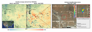
Methane concentrations over the Permian Basin.
Owing to the importance of monitoring methane, SRON’s and GHGSat’s research teams have been working since early-2019 to detect methane hotspots. The SRON team uses data from the Copernicus Sentinel-5P satellite to detect emissions on a global scale. The GHGSat team then utilises data from GHGSat satellites to quantify and attribute the emissions to specific facilities around the world.

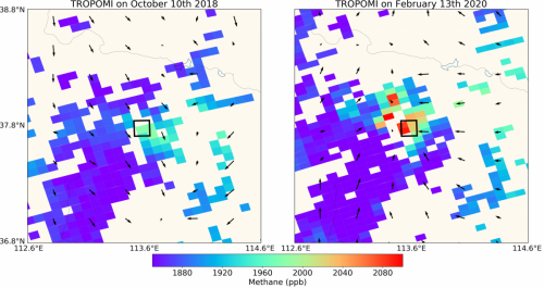
Tropomi methane measurements over a coal mine in the Shanxi province, China.
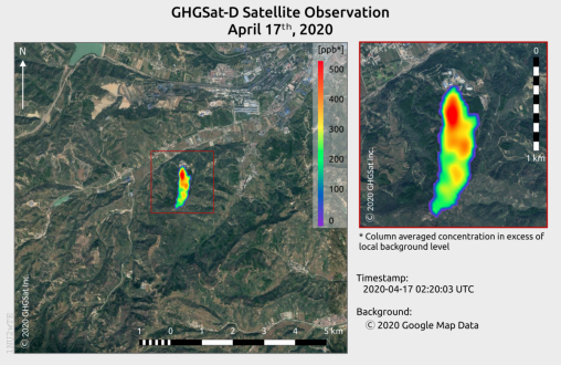
Their work has led to several new hotspots being discovered in 2020, for instance over a coal mine in China. The team have also detected methane emissions over the Permian Basin – the largest oil-producing region in the United States. The team observed concentrations from March-April 2020, compared to the same period as last year in an effort to evaluate the impact of COVID-19 activities on methane emissions.

GHGSat methane concentrations over a coal mine in the Shanxi province, China.
An initial look at these data suggest a substantial increase in methane concentrations in 2020, compared to 2019. Claus Zehner, ESA’s Copernicus Sentinel-5P mission manager, says, “An explanation for this could be that as a result of less demand for gas because of COVID-19, it is burned and vented – leading to higher methane emissions over this area.”
Ilse Aben, from SRON, comments, “However, these results are inconclusive when using only Sentinel-5P data in the Permian Basin as the number of observations are limited.”
The spatial distribution of Sentinel-5P concentrations in 2020 and in 2019 both indicate local enhancements of methane concentrations in the Delaware and Midland portions of the basin. But higher-resolution measurements, such as those provided by GHGSat, are needed to attribute these enhancements to specific facilities.
The joint analysis of GHGSat and Sentinel-5P regional methane data will continue to explore and quantify how COVID-19 is affecting emissions from the natural gas industry on a regional scale – all the way down to the level of industrial facilities.
Stephane Germain, CEO of GHGSat, comments, “GHGSat continues to work closely with ESA and SRON’s Sentinel-5P science team. We are advancing the science of satellite measurements of atmospheric trace gases while simultaneously providing practical information to industrial operators to reduce facility-level emissions. GHGSat’s next satellites, scheduled to launch in June and December of this year, will help improve our collective understanding of industrial emissions around the world."
Eric Laliberté, Director General Utilization from the Canadian Space Agency, says, “The Canadian Space Agency is committed to developing space technologies and supporting innovative missions to better understand and mitigate climate change. The results achieved by GHGSat are already having an impact and we are excited to continue working with GHGSat and ESA to better understand greenhouse gas emissions worldwide."
Claus adds, “In order to further support the scientific uptake of GHGSat measurements, ESA has organised, together with the Canadian Space Agency and GHGSat, a dedicated Announcement of Opportunity Call that will provide around 5% of the measurement capacity of the upcoming commercial GHGSat-C1, also known as the Iris satellite, to the scientific community.”
The Copernicus Sentinel-5P satellite, with its state-of-the-art instrument Tropomi, can also map other pollutants such as nitrogen dioxide, carbon monoxide, sulphur dioxide and aerosols – all of which affect the air we breathe.
Source: European Space Agency
- 248 reads
Human Rights
Ringing FOWPAL’s Peace Bell for the World:Nobel Peace Prize Laureates’ Visions and Actions

Protecting the World’s Cultural Diversity for a Sustainable Future

The Peace Bell Resonates at the 27th Eurasian Economic Summit

Declaration of World Day of the Power of Hope Endorsed by People in 158 Nations

Puppet Show I International Friendship Day 2020

