Mato Grosso, Brazil
The Copernicus Sentinel-1 mission takes us over part of the Brazilian state of Mato Grosso deep in the Amazon interior.

Mato Grosso, Brazil
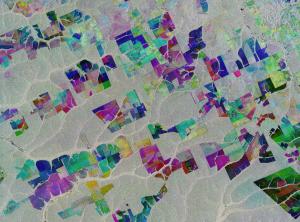
This image combines three separate radar images from the Copernicus Sentinel-1 mission taken about two years apart to show change in crops and land cover over time.
Unlike images from satellites carrying optical or ‘camera-like’ instruments, images acquired with imaging radar are interpreted by studying the intensity of the backscatter radar signal, which is related to the roughness of the ground.
Here, the first image, from 2 May 2015, is picked out in blue; the second, from 16 March 2017, picks out changes in green; and the third from 18 March 2019 in red; areas in grey depict little or no change between 2015 and 2019.
Ironically, Mato Grosso means ‘great woods’, but, as these coloured rectangular shapes portray, much of the tropical forest has been cut down and given over to farming. While this image only shows a small area, Mato Grosso is one of Brazil’s top cattle-producing and crop-producing states, with the main crops including corn, soya and wheat.
However, although the state has one of the highest historical rates of deforestation in Amazonian Brazil, deforestation is slowing and Mato Grosso is now said to be a global leader in climate-change solutions.
As an advanced radar mission, Copernicus Sentinel-1 can image the surface of Earth through cloud and rain and regardless of whether it is day or night. This makes it ideal for monitoring areas that tend to be covered by cloud such as rainforests.
Source: European Space Agency
- 246 reads
Human Rights
Ringing FOWPAL’s Peace Bell for the World:Nobel Peace Prize Laureates’ Visions and Actions

Protecting the World’s Cultural Diversity for a Sustainable Future

The Peace Bell Resonates at the 27th Eurasian Economic Summit

Declaration of World Day of the Power of Hope Endorsed by People in 158 Nations

Puppet Show I International Friendship Day 2020

