Arctic sea ice reaches fourth lowest extent in the satellite record
Arctic sea ice cover appears to have reached its minimum extent on September 11, 2015. Sea ice extent on that day was measured at 4.41 million square kilometers (1.70 million square miles). It was the fourth lowest extent recorded since satellites began measuring sea ice in 1979.
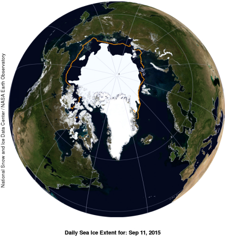
This image shows a view of the Arctic on September 11, 2015 when sea ice extent was at 4.41 million square kilometers (1.70 million square miles). The orange line shows the 1981 to 2010 average extent for that day. The black cross indicates the geographic North Pole. Sea Ice Index data. About the data.
Please note that the Arctic sea ice extent number is preliminary—changing winds could still push the ice extent lower. NSIDC will issue a formal announcement at the beginning of October with full analysis of the possible causes behind this year's ice conditions, particularly interesting aspects of the melt season, the set up going into the winter growth season ahead, and graphics comparing this year to the long-term record.
Source: U.S. National Snow and Ice Data Center
- 288 reads
Human Rights
Fostering a More Humane World: The 28th Eurasian Economic Summi

Conscience, Hope, and Action: Keys to Global Peace and Sustainability


Ringing FOWPAL’s Peace Bell for the World:Nobel Peace Prize Laureates’ Visions and Actions

Protecting the World’s Cultural Diversity for a Sustainable Future


Puppet Show I International Friendship Day 2020